The development and implementation of infrastructure projects, large and small, rely on predictability and foresight. Even the most straightforward physical observation of the progress of civil works on the ground, which may not necessarily require sophisticated equipment and expertise, depends on access to construction sites.
The past two anni horribiles have challenged many to figure out how to continue delivering needed infrastructure projects while facing tough travel restrictions. The Asian Infrastructure Investment Bank (AIIB) responded to this challenge by embracing a novel approach—by making use of ultra-high resolution satellite observations, and more importantly, making these high-resolution images available to project teams. Once we were able to download the images required to monitor our infrastructure projects, we could then conduct and rapidly scale up remote assessments from the safety of our desks.
Evaluating the progress of infrastructure projects on the ground from a distance is not new. Decades ago, sensors were attached to planes and later, to satellites, to acquire information in the form of electromagnetic energy which travels as waves. For example, the reflection of light enables optical sensors to snap pictures of the Earth’s surface much like how we take pictures with our cellphones.
The proliferation of remote sensing has normalized the use of high-resolution satellite imagery in our everyday life. Long gone are the days when this domain was exclusively restricted to governmental and security agencies. We have never had more detailed and readily available access to the images of our Earth. Unfortunately, the drawback of free services is that they are not always able to provide images across a timeline that would allow us to before and after images.
For this reason, AIIB piloted the use of ultra-high resolution satellite imagery which can provide unprecedented details about a project timeline upon request. The cost-benefit of using such a service is very favorable, as obtaining access to this data is much cheaper than the traditional alternative of an onsite visit (which is impossible during the time of the pandemic). Having acquired the data, we faced the question of how to make best use of it.
Traditionally, access to and interpretation of these images required technical background, preferably in geographic information systems (GIS). Some organizations had developed dedicated teams of experts who could extract data and provide comprehensive analysis, though this remains quite niche. This approach naturally created silos between the GIS specialists and the actual users, not to mention the time it took to process requests.
AIIB did not have the luxury of an existing GIS team on standby or the ability to form one on a short notice. It was also impractical to even consider remotely cramming highly specialized technical trainings in between our colleagues’ other tasks.
Our solution was to empower project staff, who were mostly non-GIS experts, to use ultra-high resolution satellite images in whichever way they could. AIIB investment operations officers were given a light orientation of what remote assessment is and how to use the commercially available platform. This short onboarding of a few hours was sufficient to equip them with the skills necessary to perform a visual comparison of a time series of images. While we knew that we would not be able to extract all the information encoded in the raw data, even being able to simply compare before and after pictures of the same location was enough to gain a better understanding of project progress.
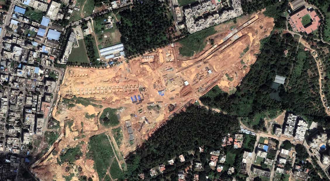
As can be seen from the examples below, it doesn’t take an expert to recognize the progress of the construction of the following AIIB-financed projects.
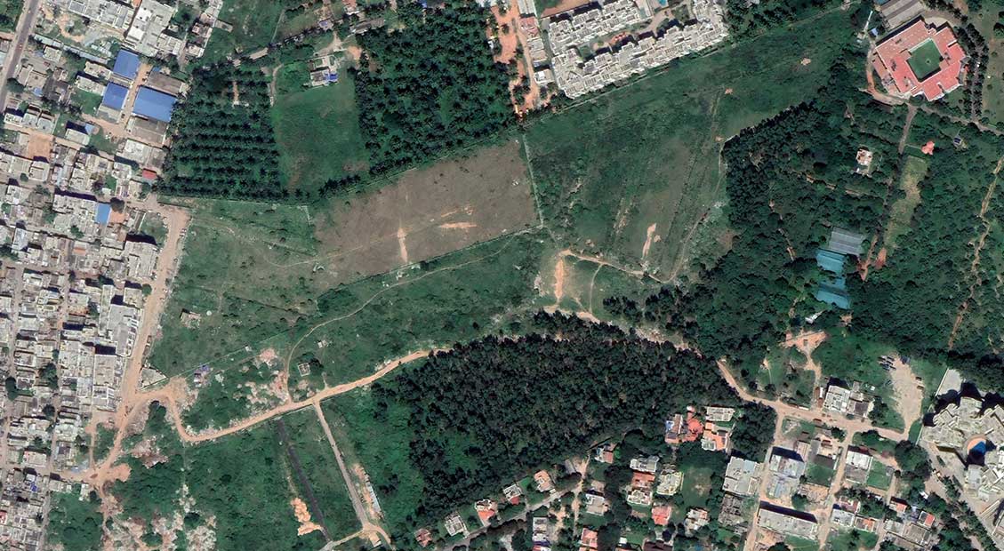

Line R6 of the Bangalore Metro Rail Project takes shape. Photos show the progress of construction from 2017 to 2021. Once finished, this AIIB-financed transportation project will expand the city's metro system and provide the people of Bengaluru, in Karnataka State in India, with an efficient, safe and fast way to travel.
Our experience at AIIB of partially mitigating the impact of travel restrictions is of import, as our investment specialists and project teams have a wide range of backgrounds, but not necessarily in the use of remote sensing or GIS technology. Instead of asking Bank staff to learn a specialized program on short notice, we made use of technology that was already familiar and available to them. This allowed us to quickly scale up and mainstream remote assessment within a short period of time and without setting up and spending on dedicated teams. We were also able to avoid bottlenecks and additional bureaucratic layers since anyone who needed to use the system could do so at their convenience.
Having set this arrangement in place, we started slowly incorporating remote assessment in our project cycle—from initial screening, environmental and social due diligence, and monitoring. While we do not use this tool or approach for all our projects, the overall experience has been positive. We are now able to complement online discussions with our clients and local consultants with satellite images, wherever possible.
What is perhaps most important is our reliance on non-GIS experts to embrace and mainstream the technology. It has empowered Bank staff to acquire new skills and independently build on their ability to remotely evaluate changes on the ground using high-resolution satellite imagery.
Remote assessment will continue to play a role in a world even when travel restrictions are lifted, and the world returns to normal. It is highly unlikely that the ease and cost of air travel will reach pre-pandemic levels any time soon. Further, the carbon footprint of business travel cannot be ignored. Thus, we see a tremendous potential for the use of remote assessment in project preparation, implementation, and monitoring. The prospects of even more advanced and cost-competitive technological options, assisted by artificial intelligence, point to a future where the sky is not a limit, but an enabler.
